|
|
|||||||||||||||||
| Point ID: 8245 | Downloads | Plots | Site Data | Code: 8318 |
|
|
|||||||||||||||||
| Download | |
|---|---|
| Site Descriptor Information | Site Time Series Data |
| Link to all available data | |
| View: | Time Series | All |
| Units: | m3/s |
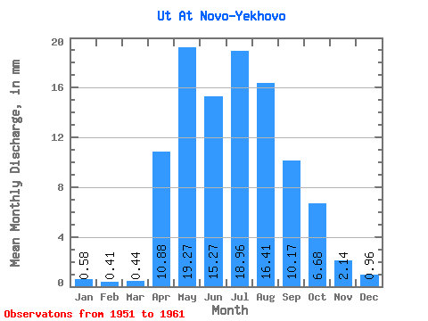
| Statistic | Jan | Feb | Mar | Apr | May | Jun | Jul | Aug | Sep | Oct | Nov | Dec | Annual |
|---|---|---|---|---|---|---|---|---|---|---|---|---|---|
| Mean | 0.58 | 0.42 | 0.44 | 10.88 | 19.27 | 15.28 | 18.95 | 16.41 | 10.17 | 6.68 | 2.14 | 0.95 | 105.52 |
| Standard Deviation | 0.49 | 0.40 | 0.42 | 5.40 | 13.09 | 7.74 | 12.41 | 13.40 | 5.90 | 2.80 | 1.03 | 0.39 | 44.52 |
| Min | 0.00 | 0.00 | 0.00 | 3.56 | 6.75 | 7.53 | 5.78 | 4.24 | 2.84 | 2.54 | 0.97 | 0.47 | 60.73 |
| Max | 1.37 | 1.13 | 1.14 | 19.81 | 46.41 | 30.38 | 44.08 | 49.09 | 20.04 | 10.99 | 3.56 | 1.64 | 182.46 |
| Coefficient of Variation | 0.85 | 0.95 | 0.96 | 0.50 | 0.68 | 0.51 | 0.66 | 0.82 | 0.58 | 0.42 | 0.48 | 0.41 | 0.42 |
 Return to R-Arctic Net Home Page