|
|
|||||||||||||||||
| Point ID: 8243 | Downloads | Plots | Site Data | Code: 8316 |
|
|
|||||||||||||||||
| Download | |
|---|---|
| Site Descriptor Information | Site Time Series Data |
| Link to all available data | |
| View: | Time Series | All |
| Units: | m3/s |
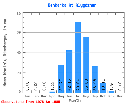
| Statistic | Jan | Feb | Mar | Apr | May | Jun | Jul | Aug | Sep | Oct | Nov | Dec | Annual |
|---|---|---|---|---|---|---|---|---|---|---|---|---|---|
| Mean | 0.00 | 0.00 | 0.04 | 1.23 | 27.79 | 42.17 | 70.65 | 55.61 | 26.50 | 10.13 | 1.91 | 0.04 | 234.69 |
| Standard Deviation | 0.00 | 0.00 | 0.14 | 1.37 | 16.75 | 17.09 | 74.57 | 33.60 | 25.06 | 8.28 | 1.80 | 0.14 | 143.09 |
| Min | 0.00 | 0.00 | 0.00 | 0.00 | 11.77 | 22.79 | 2.26 | 16.68 | 4.65 | 2.26 | 0.00 | 0.00 | 109.82 |
| Max | 0.00 | 0.00 | 0.49 | 4.46 | 66.70 | 81.65 | 260.93 | 111.83 | 93.05 | 31.39 | 4.94 | 0.49 | 602.59 |
| Coefficient of Variation | 3.46 | 1.11 | 0.60 | 0.41 | 1.05 | 0.60 | 0.94 | 0.82 | 0.94 | 3.61 | 0.61 |
 Return to R-Arctic Net Home Page