|
|
|||||||||||||||||
| Point ID: 8213 | Downloads | Plots | Site Data | Code: 8228 |
|
|
|||||||||||||||||
| Download | |
|---|---|
| Site Descriptor Information | Site Time Series Data |
| Link to all available data | |
| View: | Time Series | All |
| Units: | m3/s |
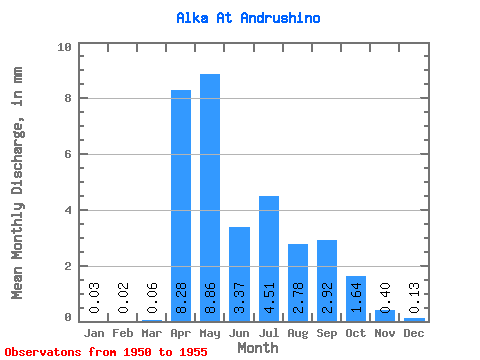
| Statistic | Jan | Feb | Mar | Apr | May | Jun | Jul | Aug | Sep | Oct | Nov | Dec | Annual |
|---|---|---|---|---|---|---|---|---|---|---|---|---|---|
| Mean | 0.03 | 0.02 | 0.06 | 8.28 | 8.87 | 3.37 | 4.51 | 2.78 | 2.92 | 1.64 | 0.40 | 0.13 | 38.19 |
| Standard Deviation | 0.05 | 0.03 | 0.08 | 4.93 | 2.66 | 2.33 | 3.06 | 3.16 | 3.72 | 1.15 | 0.23 | 0.18 | 13.45 |
| Min | 0.00 | 0.00 | 0.00 | 1.61 | 6.92 | 1.06 | 1.43 | 0.95 | 0.43 | 0.43 | 0.15 | 0.00 | 25.95 |
| Max | 0.08 | 0.06 | 0.15 | 14.31 | 13.46 | 5.92 | 8.96 | 8.39 | 10.23 | 3.08 | 0.73 | 0.36 | 52.59 |
| Coefficient of Variation | 1.73 | 1.73 | 1.19 | 0.60 | 0.30 | 0.69 | 0.68 | 1.14 | 1.27 | 0.70 | 0.56 | 1.38 | 0.35 |
 Return to R-Arctic Net Home Page