|
|
|||||||||||||||||
| Point ID: 8202 | Downloads | Plots | Site Data | Code: 8197 |
|
|
|||||||||||||||||
| Download | |
|---|---|
| Site Descriptor Information | Site Time Series Data |
| Link to all available data | |
| View: | Time Series | All |
| Units: | m3/s |
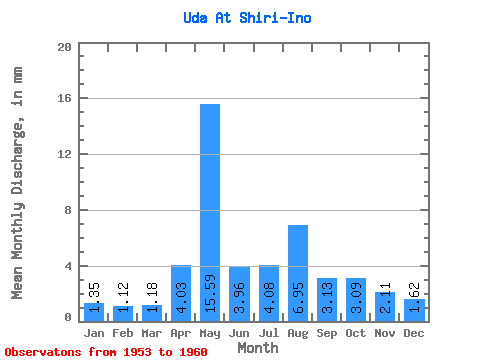
| Statistic | Jan | Feb | Mar | Apr | May | Jun | Jul | Aug | Sep | Oct | Nov | Dec | Annual |
|---|---|---|---|---|---|---|---|---|---|---|---|---|---|
| Mean | 1.35 | 1.13 | 1.18 | 4.03 | 15.59 | 3.96 | 4.08 | 6.95 | 3.13 | 3.09 | 2.11 | 1.61 | 44.87 |
| Standard Deviation | 0.74 | 0.61 | 0.56 | 2.52 | 6.83 | 1.76 | 3.11 | 7.18 | 2.40 | 1.98 | 1.63 | 1.20 | 18.75 |
| Min | 0.63 | 0.52 | 0.59 | 2.12 | 8.21 | 1.93 | 1.56 | 1.65 | 1.38 | 1.36 | 0.81 | 0.61 | 24.46 |
| Max | 2.66 | 2.19 | 1.94 | 8.73 | 24.31 | 7.30 | 9.68 | 21.50 | 7.82 | 6.81 | 5.62 | 4.13 | 73.97 |
| Coefficient of Variation | 0.55 | 0.54 | 0.48 | 0.62 | 0.44 | 0.45 | 0.76 | 1.03 | 0.77 | 0.64 | 0.78 | 0.74 | 0.42 |
 Return to R-Arctic Net Home Page