|
|
|||||||||||||||||
| Point ID: 8190 | Downloads | Plots | Site Data | Code: 8175 |
|
|
|||||||||||||||||
| Download | |
|---|---|
| Site Descriptor Information | Site Time Series Data |
| Link to all available data | |
| View: | Time Series | All |
| Units: | m3/s |
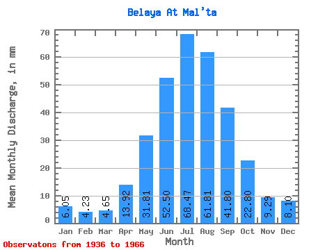
| Statistic | Jan | Feb | Mar | Apr | May | Jun | Jul | Aug | Sep | Oct | Nov | Dec | Annual |
|---|---|---|---|---|---|---|---|---|---|---|---|---|---|
| Mean | 6.04 | 4.27 | 4.64 | 13.92 | 31.80 | 52.50 | 68.46 | 61.80 | 41.80 | 22.79 | 9.29 | 8.10 | 323.82 |
| Standard Deviation | 1.11 | 0.78 | 0.79 | 5.20 | 8.89 | 16.31 | 26.43 | 15.27 | 10.34 | 3.74 | 1.82 | 1.23 | 46.50 |
| Min | 3.21 | 2.26 | 2.40 | 4.14 | 17.50 | 33.28 | 36.06 | 41.69 | 28.86 | 17.04 | 6.55 | 5.51 | 240.20 |
| Max | 7.71 | 5.77 | 6.18 | 25.77 | 56.15 | 90.57 | 151.70 | 97.23 | 75.26 | 30.58 | 13.06 | 10.24 | 442.51 |
| Coefficient of Variation | 0.18 | 0.18 | 0.17 | 0.37 | 0.28 | 0.31 | 0.39 | 0.25 | 0.25 | 0.16 | 0.20 | 0.15 | 0.14 |
 Return to R-Arctic Net Home Page