|
|
|||||||||||||||||
| Point ID: 8177 | Downloads | Plots | Site Data | Code: 8149 |
|
|
|||||||||||||||||
| Download | |
|---|---|
| Site Descriptor Information | Site Time Series Data |
| Link to all available data | |
| View: | Time Series | All |
| Units: | m3/s |
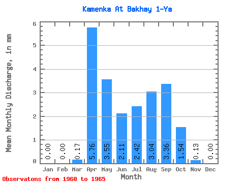
| Statistic | Jan | Feb | Mar | Apr | May | Jun | Jul | Aug | Sep | Oct | Nov | Dec | Annual |
|---|---|---|---|---|---|---|---|---|---|---|---|---|---|
| Mean | 0.00 | 0.00 | 0.17 | 5.76 | 3.54 | 2.12 | 2.42 | 3.04 | 3.36 | 1.54 | 0.13 | 0.00 | 22.70 |
| Standard Deviation | 0.00 | 0.00 | 0.37 | 1.25 | 2.63 | 1.41 | 0.81 | 2.28 | 4.73 | 1.14 | 0.20 | 0.00 | 12.57 |
| Min | 0.00 | 0.00 | 0.00 | 4.14 | 1.81 | 0.81 | 1.63 | 0.44 | 0.45 | 0.44 | 0.00 | 0.00 | 13.22 |
| Max | 0.00 | 0.00 | 0.84 | 6.93 | 7.39 | 4.28 | 3.63 | 6.09 | 11.74 | 3.44 | 0.54 | 0.00 | 41.09 |
| Coefficient of Variation | 2.24 | 0.22 | 0.74 | 0.67 | 0.33 | 0.75 | 1.41 | 0.74 | 1.55 | 0.55 |
 Return to R-Arctic Net Home Page