|
|
|||||||||||||||||
| Point ID: 8139 | Downloads | Plots | Site Data | Code: 7192 |
|
|
|||||||||||||||||
| Download | |
|---|---|
| Site Descriptor Information | Site Time Series Data |
| Link to all available data | |
| View: | Time Series | All |
| Units: | m3/s |
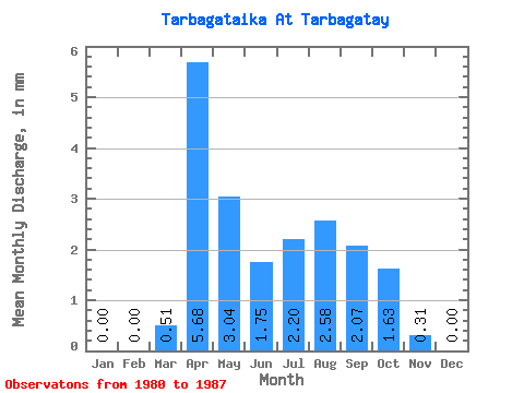
| Statistic | Jan | Feb | Mar | Apr | May | Jun | Jul | Aug | Sep | Oct | Nov | Dec | Annual |
|---|---|---|---|---|---|---|---|---|---|---|---|---|---|
| Mean | 0.00 | 0.00 | 0.51 | 5.68 | 3.04 | 1.74 | 2.20 | 2.58 | 2.08 | 1.63 | 0.31 | 0.00 | 20.49 |
| Standard Deviation | 0.00 | 0.00 | 0.58 | 2.55 | 1.68 | 0.72 | 0.66 | 1.24 | 1.53 | 0.70 | 0.26 | 0.00 | 8.52 |
| Min | 0.00 | 0.00 | 0.00 | 2.66 | 1.55 | 0.65 | 1.31 | 1.44 | 0.89 | 0.96 | 0.05 | 0.00 | 13.14 |
| Max | 0.00 | 0.00 | 1.31 | 10.07 | 6.82 | 2.89 | 3.11 | 4.54 | 4.86 | 3.11 | 0.65 | 0.00 | 32.69 |
| Coefficient of Variation | 1.13 | 0.45 | 0.56 | 0.41 | 0.30 | 0.48 | 0.74 | 0.43 | 0.83 | 0.42 |
 Return to R-Arctic Net Home Page