|
|
|||||||||||||||||
| Point ID: 8135 | Downloads | Plots | Site Data | Code: 1803 |
|
|
|||||||||||||||||
| Download | |
|---|---|
| Site Descriptor Information | Site Time Series Data |
| Link to all available data | |
| View: | Time Series | All |
| Units: | m3/s |
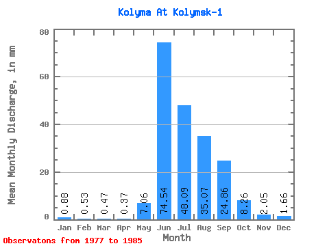
| Statistic | Jan | Feb | Mar | Apr | May | Jun | Jul | Aug | Sep | Oct | Nov | Dec | Annual |
|---|---|---|---|---|---|---|---|---|---|---|---|---|---|
| Mean | 0.88 | 0.53 | 0.47 | 0.37 | 7.06 | 74.54 | 48.08 | 35.07 | 24.86 | 8.26 | 2.05 | 1.66 | 203.55 |
| Standard Deviation | 0.34 | 0.20 | 0.21 | 0.17 | 6.11 | 30.06 | 25.17 | 8.76 | 9.12 | 2.56 | 0.55 | 0.52 | 56.41 |
| Min | 0.38 | 0.27 | 0.22 | 0.15 | 1.55 | 36.42 | 17.21 | 21.54 | 14.78 | 4.71 | 1.45 | 1.01 | 112.28 |
| Max | 1.42 | 0.82 | 0.83 | 0.69 | 18.68 | 129.11 | 89.61 | 45.92 | 43.17 | 13.29 | 2.97 | 2.62 | 291.17 |
| Coefficient of Variation | 0.38 | 0.38 | 0.45 | 0.46 | 0.87 | 0.40 | 0.52 | 0.25 | 0.37 | 0.31 | 0.27 | 0.32 | 0.28 |
 Return to R-Arctic Net Home Page