|
|
|||||||||||||||||
| Point ID: 8132 | Downloads | Plots | Site Data | Code: 1623 |
|
|
|||||||||||||||||
| Download | |
|---|---|
| Site Descriptor Information | Site Time Series Data |
| Link to all available data | |
| View: | Time Series | All |
| Units: | m3/s |
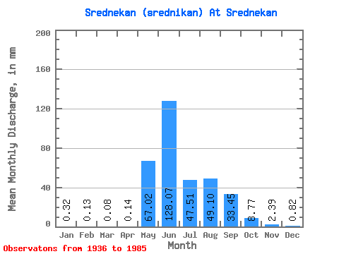
| Statistic | Jan | Feb | Mar | Apr | May | Jun | Jul | Aug | Sep | Oct | Nov | Dec | Annual |
|---|---|---|---|---|---|---|---|---|---|---|---|---|---|
| Mean | 0.32 | 0.14 | 0.08 | 0.14 | 67.01 | 128.07 | 47.50 | 49.09 | 33.45 | 8.77 | 2.39 | 0.82 | 337.10 |
| Standard Deviation | 0.33 | 0.21 | 0.15 | 0.40 | 40.37 | 77.78 | 29.82 | 31.87 | 21.51 | 4.76 | 1.20 | 0.52 | 88.86 |
| Min | 0.00 | 0.00 | 0.00 | 0.00 | 0.23 | 17.98 | 13.87 | 10.17 | 9.32 | 2.12 | 0.64 | 0.03 | 213.00 |
| Max | 1.19 | 0.73 | 0.56 | 2.70 | 185.76 | 353.59 | 137.77 | 184.21 | 115.67 | 23.84 | 5.71 | 2.10 | 580.49 |
| Coefficient of Variation | 1.03 | 1.54 | 1.80 | 2.83 | 0.60 | 0.61 | 0.63 | 0.65 | 0.64 | 0.54 | 0.50 | 0.63 | 0.26 |
 Return to R-Arctic Net Home Page