|
|
|||||||||||||||||
| Point ID: 8128 | Downloads | Plots | Site Data | Code: 1617 |
|
|
|||||||||||||||||
| Download | |
|---|---|
| Site Descriptor Information | Site Time Series Data |
| Link to all available data | |
| View: | Time Series | All |
| Units: | m3/s |
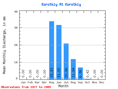
| Statistic | Jan | Feb | Mar | Apr | May | Jun | Jul | Aug | Sep | Oct | Nov | Dec | Annual |
|---|---|---|---|---|---|---|---|---|---|---|---|---|---|
| Mean | 0.00 | 0.00 | 0.00 | 0.00 | 33.83 | 31.59 | 20.88 | 11.81 | 6.94 | 0.42 | 0.00 | 0.00 | 104.83 |
| Standard Deviation | 0.00 | 0.00 | 0.00 | 0.00 | 14.16 | 18.38 | 16.43 | 8.98 | 6.94 | 0.91 | 0.00 | 0.00 | 42.70 |
| Min | 0.00 | 0.00 | 0.00 | 0.00 | 14.10 | 7.91 | 5.21 | 1.27 | 0.27 | 0.00 | 0.00 | 0.00 | 35.57 |
| Max | 0.00 | 0.00 | 0.00 | 0.00 | 52.15 | 58.66 | 52.29 | 25.37 | 20.46 | 2.82 | 0.00 | 0.00 | 190.41 |
| Coefficient of Variation | 0.42 | 0.58 | 0.79 | 0.76 | 1.00 | 2.16 | 0.41 |
 Return to R-Arctic Net Home Page