|
|
|||||||||||||||||
| Point ID: 8123 | Downloads | Plots | Site Data | Code: 1606 |
|
|
|||||||||||||||||
| Download | |
|---|---|
| Site Descriptor Information | Site Time Series Data |
| Link to all available data | |
| View: | Time Series | All |
| Units: | m3/s |
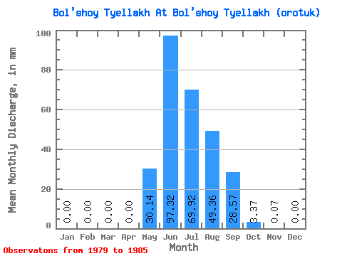
| Statistic | Jan | Feb | Mar | Apr | May | Jun | Jul | Aug | Sep | Oct | Nov | Dec | Annual |
|---|---|---|---|---|---|---|---|---|---|---|---|---|---|
| Mean | 0.00 | 0.00 | 0.00 | 0.00 | 30.14 | 97.33 | 69.91 | 49.35 | 28.57 | 3.37 | 0.07 | 0.00 | 277.86 |
| Standard Deviation | 0.00 | 0.00 | 0.00 | 0.00 | 14.69 | 56.73 | 23.89 | 16.27 | 16.17 | 1.92 | 0.05 | 0.00 | 60.94 |
| Min | 0.00 | 0.00 | 0.00 | 0.00 | 7.18 | 44.36 | 32.19 | 29.10 | 12.88 | 2.14 | 0.01 | 0.00 | 199.65 |
| Max | 0.00 | 0.00 | 0.00 | 0.01 | 52.53 | 181.69 | 100.94 | 71.33 | 56.58 | 7.21 | 0.14 | 0.00 | 337.66 |
| Coefficient of Variation | 2.45 | 0.49 | 0.58 | 0.34 | 0.33 | 0.57 | 0.57 | 0.75 | 0.22 |
 Return to R-Arctic Net Home Page