|
|
|||||||||||||||||
| Point ID: 811 | Downloads | Plots | Site Data | Code: 07OB005 |
|
|
|||||||||||||||||
| Download | |
|---|---|
| Site Descriptor Information | Site Time Series Data |
| Link to all available data | |
| View: | Time Series | All |
| Units: | m3/s |
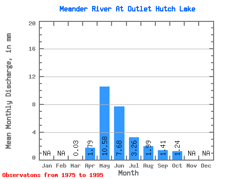
| Statistic | Jan | Feb | Mar | Apr | May | Jun | Jul | Aug | Sep | Oct | Nov | Dec | Annual |
|---|---|---|---|---|---|---|---|---|---|---|---|---|---|
| Mean | 0.03 | 1.79 | 10.58 | 7.68 | 3.27 | 1.98 | 1.40 | 1.23 | |||||
| Standard Deviation | 0.06 | 3.81 | 10.97 | 11.29 | 5.31 | 4.78 | 2.54 | 1.81 | |||||
| Min | 0.00 | 0.04 | 0.07 | 0.01 | 0.00 | 0.00 | 0.00 | 0.00 | |||||
| Max | 0.20 | 15.44 | 41.36 | 38.19 | 15.58 | 20.07 | 9.20 | 5.27 | |||||
| Coefficient of Variation | 1.80 | 2.13 | 1.04 | 1.47 | 1.62 | 2.41 | 1.81 | 1.46 |
 Return to R-Arctic Net Home Page