|
|
|||||||||||||||||
| Point ID: 8108 | Downloads | Plots | Site Data | Code: 1567 |
|
|
|||||||||||||||||
| Download | |
|---|---|
| Site Descriptor Information | Site Time Series Data |
| Link to all available data | |
| View: | Time Series | All |
| Units: | m3/s |
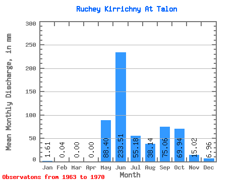
| Statistic | Jan | Feb | Mar | Apr | May | Jun | Jul | Aug | Sep | Oct | Nov | Dec | Annual |
|---|---|---|---|---|---|---|---|---|---|---|---|---|---|
| Mean | 1.60 | 0.06 | 0.00 | 0.00 | 88.38 | 233.49 | 55.16 | 38.12 | 75.04 | 69.93 | 15.02 | 6.96 | 581.26 |
| Standard Deviation | 1.78 | 0.09 | 0.00 | 0.00 | 51.27 | 82.97 | 31.26 | 15.42 | 80.92 | 38.93 | 5.09 | 4.51 | 212.16 |
| Min | 0.00 | 0.00 | 0.00 | 0.00 | 32.17 | 109.91 | 24.13 | 20.82 | 16.03 | 32.65 | 9.62 | 1.99 | 391.94 |
| Max | 4.73 | 0.22 | 0.00 | 0.00 | 166.55 | 323.31 | 103.19 | 64.35 | 249.12 | 130.59 | 22.90 | 12.78 | 885.42 |
| Coefficient of Variation | 1.11 | 1.48 | 0.58 | 0.35 | 0.57 | 0.41 | 1.08 | 0.56 | 0.34 | 0.65 | 0.36 |
 Return to R-Arctic Net Home Page