|
|
|||||||||||||||||
| Point ID: 8105 | Downloads | Plots | Site Data | Code: 1563 |
|
|
|||||||||||||||||
| Download | |
|---|---|
| Site Descriptor Information | Site Time Series Data |
| Link to all available data | |
| View: | Time Series | All |
| Units: | m3/s |
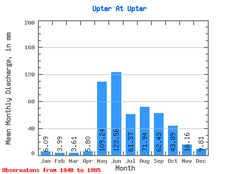
| Statistic | Jan | Feb | Mar | Apr | May | Jun | Jul | Aug | Sep | Oct | Nov | Dec | Annual |
|---|---|---|---|---|---|---|---|---|---|---|---|---|---|
| Mean | 6.09 | 4.02 | 3.60 | 5.80 | 109.22 | 123.56 | 61.36 | 71.93 | 62.43 | 43.88 | 16.16 | 9.81 | 515.06 |
| Standard Deviation | 2.79 | 2.61 | 2.57 | 2.67 | 23.16 | 80.28 | 33.08 | 34.80 | 28.22 | 27.84 | 6.85 | 3.12 | 127.40 |
| Min | 0.62 | 0.27 | 0.19 | 2.25 | 73.97 | 35.21 | 24.76 | 32.03 | 26.02 | 16.98 | 8.80 | 4.04 | 320.91 |
| Max | 10.52 | 8.29 | 7.07 | 13.30 | 153.61 | 289.52 | 129.35 | 150.57 | 107.59 | 119.25 | 31.98 | 14.86 | 792.50 |
| Coefficient of Variation | 0.46 | 0.65 | 0.71 | 0.46 | 0.21 | 0.65 | 0.54 | 0.48 | 0.45 | 0.63 | 0.42 | 0.32 | 0.25 |
 Return to R-Arctic Net Home Page