|
|
|||||||||||||||||
| Point ID: 8100 | Downloads | Plots | Site Data | Code: 1545 |
|
|
|||||||||||||||||
| Download | |
|---|---|
| Site Descriptor Information | Site Time Series Data |
| Link to all available data | |
| View: | Time Series | All |
| Units: | m3/s |
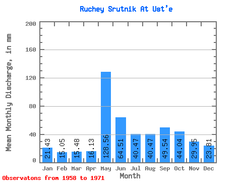
| Statistic | Jan | Feb | Mar | Apr | May | Jun | Jul | Aug | Sep | Oct | Nov | Dec | Annual |
|---|---|---|---|---|---|---|---|---|---|---|---|---|---|
| Mean | 21.64 | 15.54 | 15.87 | 16.26 | 128.62 | 65.02 | 40.20 | 41.00 | 49.66 | 43.51 | 30.08 | 23.94 | 489.22 |
| Standard Deviation | 5.45 | 3.80 | 4.17 | 3.13 | 62.83 | 40.77 | 17.70 | 14.08 | 19.38 | 14.97 | 8.05 | 4.01 | 128.65 |
| Min | 14.28 | 10.84 | 10.71 | 12.67 | 73.79 | 31.10 | 23.80 | 29.76 | 26.50 | 25.00 | 19.58 | 19.04 | 367.03 |
| Max | 30.47 | 21.69 | 23.80 | 21.89 | 248.76 | 149.76 | 80.94 | 69.03 | 82.94 | 66.65 | 43.78 | 28.57 | 714.89 |
| Coefficient of Variation | 0.25 | 0.24 | 0.26 | 0.19 | 0.49 | 0.63 | 0.44 | 0.34 | 0.39 | 0.34 | 0.27 | 0.17 | 0.26 |
 Return to R-Arctic Net Home Page