|
|
|||||||||||||||||
| Point ID: 8099 | Downloads | Plots | Site Data | Code: 1544 |
|
|
|||||||||||||||||
| Download | |
|---|---|
| Site Descriptor Information | Site Time Series Data |
| Link to all available data | |
| View: | Time Series | All |
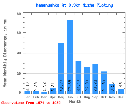
| Units: | m3/s |
| Statistic | Jan | Feb | Mar | Apr | May | Jun | Jul | Aug | Sep | Oct | Nov | Dec | Annual |
|---|---|---|---|---|---|---|---|---|---|---|---|---|---|
| Mean | 3.10 | 2.36 | 1.91 | 5.21 | 49.77 | 72.70 | 32.45 | 26.32 | 29.26 | 21.81 | 9.26 | 4.44 | 259.37 |
| Standard Deviation | 3.68 | 3.52 | 3.05 | 8.89 | 28.58 | 69.21 | 43.71 | 22.02 | 24.91 | 15.99 | 11.34 | 6.23 | 130.32 |
| Min | 0.93 | 0.57 | 0.48 | 0.61 | 17.34 | 9.64 | 1.77 | 2.07 | 2.00 | 1.85 | 1.22 | 0.93 | 99.11 |
| Max | 13.28 | 12.79 | 11.07 | 25.35 | 94.06 | 211.36 | 138.69 | 69.35 | 77.83 | 46.11 | 32.49 | 23.24 | 526.68 |
| Coefficient of Variation | 1.19 | 1.50 | 1.59 | 1.71 | 0.57 | 0.95 | 1.35 | 0.84 | 0.85 | 0.73 | 1.23 | 1.40 | 0.50 |
 Return to R-Arctic Net Home Page