|
|
|||||||||||||||||
| Point ID: 8090 | Downloads | Plots | Site Data | Code: 1515 |
|
|
|||||||||||||||||
| Download | |
|---|---|
| Site Descriptor Information | Site Time Series Data |
| Link to all available data | |
| View: | Time Series | All |
| Units: | m3/s |
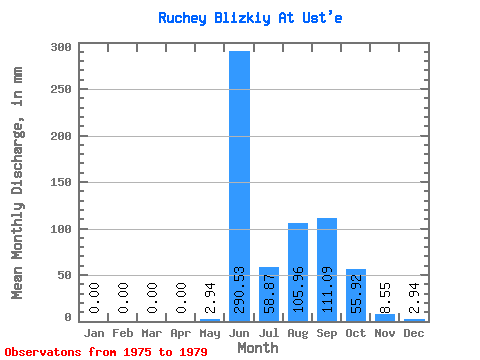
| Statistic | Jan | Feb | Mar | Apr | May | Jun | Jul | Aug | Sep | Oct | Nov | Dec | Annual |
|---|---|---|---|---|---|---|---|---|---|---|---|---|---|
| Mean | 0.00 | 0.00 | 0.00 | 0.00 | 2.65 | 290.25 | 59.59 | 105.35 | 110.63 | 55.68 | 8.32 | 1.53 | 660.82 |
| Standard Deviation | 0.00 | 0.00 | 0.00 | 0.00 | 4.20 | 58.21 | 37.02 | 81.69 | 96.26 | 33.49 | 8.61 | 2.19 | 267.89 |
| Min | 0.00 | 0.00 | 0.00 | 0.00 | 0.00 | 205.08 | 14.71 | 19.42 | 38.74 | 25.31 | 0.00 | 0.00 | 421.38 |
| Max | 0.00 | 0.00 | 0.00 | 0.00 | 8.83 | 330.41 | 103.00 | 203.06 | 273.44 | 105.94 | 19.94 | 4.71 | 1037.55 |
| Coefficient of Variation | 1.59 | 0.20 | 0.62 | 0.78 | 0.87 | 0.60 | 1.03 | 1.43 | 0.41 |
 Return to R-Arctic Net Home Page