|
|
|||||||||||||||||
| Point ID: 8088 | Downloads | Plots | Site Data | Code: 1513 |
|
|
|||||||||||||||||
| Download | |
|---|---|
| Site Descriptor Information | Site Time Series Data |
| Link to all available data | |
| View: | Time Series | All |
| Units: | m3/s |
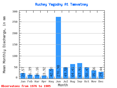
| Statistic | Jan | Feb | Mar | Apr | May | Jun | Jul | Aug | Sep | Oct | Nov | Dec | Annual |
|---|---|---|---|---|---|---|---|---|---|---|---|---|---|
| Mean | 24.61 | 16.52 | 16.11 | 13.92 | 42.40 | 271.00 | 49.66 | 64.43 | 67.93 | 50.48 | 35.64 | 29.33 | 684.06 |
| Standard Deviation | 10.20 | 5.87 | 4.31 | 2.57 | 29.17 | 97.36 | 33.00 | 40.17 | 33.31 | 17.89 | 12.35 | 9.52 | 205.59 |
| Min | 10.76 | 8.27 | 10.09 | 10.94 | 4.66 | 83.54 | 13.94 | 22.13 | 34.27 | 26.56 | 18.85 | 16.82 | 399.93 |
| Max | 39.85 | 28.25 | 24.36 | 19.51 | 101.81 | 383.44 | 123.94 | 130.73 | 135.10 | 79.68 | 55.71 | 42.05 | 977.24 |
| Coefficient of Variation | 0.41 | 0.35 | 0.27 | 0.18 | 0.69 | 0.36 | 0.66 | 0.62 | 0.49 | 0.35 | 0.35 | 0.33 | 0.30 |
 Return to R-Arctic Net Home Page