|
|
|||||||||||||||||
| Point ID: 8077 | Downloads | Plots | Site Data | Code: 1425 |
|
|
|||||||||||||||||
| Download | |
|---|---|
| Site Descriptor Information | Site Time Series Data |
| Link to all available data | |
| View: | Time Series | All |
| Units: | m3/s |
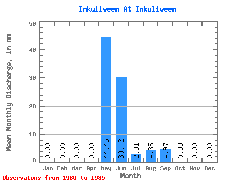
| Statistic | Jan | Feb | Mar | Apr | May | Jun | Jul | Aug | Sep | Oct | Nov | Dec | Annual |
|---|---|---|---|---|---|---|---|---|---|---|---|---|---|
| Mean | 0.00 | 0.00 | 0.00 | 0.00 | 44.44 | 30.41 | 2.91 | 4.35 | 4.97 | 0.33 | 0.00 | 0.00 | 87.00 |
| Standard Deviation | 0.00 | 0.00 | 0.00 | 0.00 | 25.83 | 36.16 | 3.60 | 6.72 | 8.52 | 0.89 | 0.00 | 0.00 | 46.07 |
| Min | 0.00 | 0.00 | 0.00 | 0.00 | 0.79 | 1.28 | 0.01 | 0.00 | 0.00 | 0.00 | 0.00 | 0.00 | 17.29 |
| Max | 0.00 | 0.00 | 0.00 | 0.00 | 103.91 | 132.81 | 15.16 | 23.57 | 36.63 | 4.32 | 0.01 | 0.00 | 214.87 |
| Coefficient of Variation | 0.58 | 1.19 | 1.24 | 1.54 | 1.72 | 2.72 | 5.10 | 0.53 |
 Return to R-Arctic Net Home Page