|
|
|||||||||||||||||
| Point ID: 8072 | Downloads | Plots | Site Data | Code: 1415 |
|
|
|||||||||||||||||
| Download | |
|---|---|
| Site Descriptor Information | Site Time Series Data |
| Link to all available data | |
| View: | Time Series | All |
| Units: | m3/s |
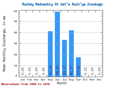
| Statistic | Jan | Feb | Mar | Apr | May | Jun | Jul | Aug | Sep | Oct | Nov | Dec | Annual |
|---|---|---|---|---|---|---|---|---|---|---|---|---|---|
| Mean | 0.00 | 0.00 | 0.00 | 0.00 | 40.98 | 58.62 | 33.11 | 41.75 | 17.59 | 0.11 | 0.00 | 0.00 | 191.20 |
| Standard Deviation | 0.00 | 0.00 | 0.00 | 0.00 | 37.71 | 43.72 | 29.90 | 23.05 | 11.79 | 0.17 | 0.00 | 0.00 | 70.08 |
| Min | 0.00 | 0.00 | 0.00 | 0.00 | 0.00 | 11.89 | 3.93 | 2.58 | 0.95 | 0.00 | 0.00 | 0.00 | 88.91 |
| Max | 0.00 | 0.00 | 0.00 | 0.00 | 153.56 | 152.19 | 116.70 | 95.82 | 43.99 | 0.61 | 0.00 | 0.00 | 304.14 |
| Coefficient of Variation | 0.92 | 0.75 | 0.90 | 0.55 | 0.67 | 1.52 | 0.37 |
 Return to R-Arctic Net Home Page