|
|
|||||||||||||||||
| Point ID: 8071 | Downloads | Plots | Site Data | Code: 1412 |
|
|
|||||||||||||||||
| Download | |
|---|---|
| Site Descriptor Information | Site Time Series Data |
| Link to all available data | |
| View: | Time Series | All |
| Units: | m3/s |
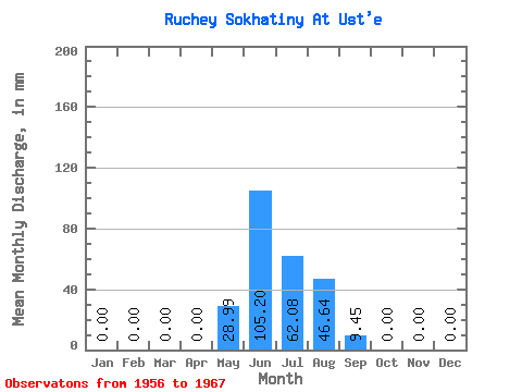
| Statistic | Jan | Feb | Mar | Apr | May | Jun | Jul | Aug | Sep | Oct | Nov | Dec | Annual |
|---|---|---|---|---|---|---|---|---|---|---|---|---|---|
| Mean | 0.00 | 0.00 | 0.00 | 0.00 | 29.13 | 105.08 | 62.04 | 46.76 | 9.39 | 0.09 | 0.00 | 0.00 | 251.68 |
| Standard Deviation | 0.00 | 0.00 | 0.00 | 0.00 | 37.62 | 54.96 | 28.73 | 26.09 | 10.70 | 0.28 | 0.00 | 0.00 | 69.06 |
| Min | 0.00 | 0.00 | 0.00 | 0.00 | 0.00 | 36.78 | 14.18 | 17.64 | 0.92 | 0.00 | 0.00 | 0.00 | 166.15 |
| Max | 0.00 | 0.00 | 0.00 | 0.00 | 129.17 | 201.26 | 113.42 | 94.52 | 36.78 | 0.94 | 0.00 | 0.00 | 355.51 |
| Coefficient of Variation | 1.29 | 0.52 | 0.46 | 0.56 | 1.14 | 3.32 | 0.27 |
 Return to R-Arctic Net Home Page