|
|
|||||||||||||||||
| Point ID: 8063 | Downloads | Plots | Site Data | Code: 1298 |
|
|
|||||||||||||||||
| Download | |
|---|---|
| Site Descriptor Information | Site Time Series Data |
| Link to all available data | |
| View: | Time Series | All |
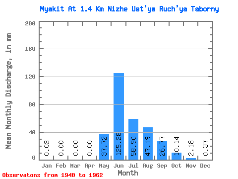
| Units: | m3/s |
| Statistic | Jan | Feb | Mar | Apr | May | Jun | Jul | Aug | Sep | Oct | Nov | Dec | Annual |
|---|---|---|---|---|---|---|---|---|---|---|---|---|---|
| Mean | 0.03 | 0.00 | 0.00 | 0.00 | 37.72 | 125.28 | 58.89 | 47.18 | 26.77 | 10.14 | 2.19 | 0.37 | 307.24 |
| Standard Deviation | 0.07 | 0.00 | 0.00 | 0.00 | 25.79 | 61.07 | 24.41 | 25.56 | 15.40 | 4.70 | 1.06 | 0.42 | 77.32 |
| Min | 0.00 | 0.00 | 0.00 | 0.00 | 1.24 | 44.21 | 22.16 | 16.41 | 11.12 | 4.98 | 0.40 | 0.00 | 170.09 |
| Max | 0.31 | 0.01 | 0.00 | 0.02 | 97.76 | 242.57 | 98.35 | 109.02 | 84.30 | 23.34 | 4.70 | 1.24 | 435.52 |
| Coefficient of Variation | 2.60 | 4.36 | 3.39 | 0.68 | 0.49 | 0.41 | 0.54 | 0.57 | 0.46 | 0.48 | 1.12 | 0.25 |
 Return to R-Arctic Net Home Page