|
|
|||||||||||||||||
| Point ID: 8059 | Downloads | Plots | Site Data | Code: 1266 |
|
|
|||||||||||||||||
| Download | |
|---|---|
| Site Descriptor Information | Site Time Series Data |
| Link to all available data | |
| View: | Time Series | All |
| Units: | m3/s |
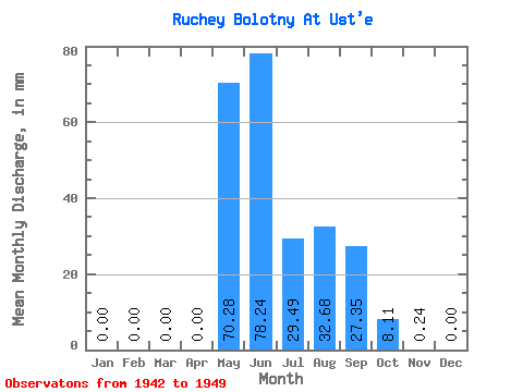
| Statistic | Jan | Feb | Mar | Apr | May | Jun | Jul | Aug | Sep | Oct | Nov | Dec | Annual |
|---|---|---|---|---|---|---|---|---|---|---|---|---|---|
| Mean | 0.00 | 0.00 | 0.00 | 0.00 | 70.33 | 78.33 | 29.42 | 32.65 | 27.23 | 8.10 | 0.27 | 0.00 | 245.34 |
| Standard Deviation | 0.00 | 0.00 | 0.00 | 0.00 | 40.45 | 85.16 | 6.72 | 13.53 | 20.49 | 11.33 | 0.50 | 0.00 | 80.54 |
| Min | 0.00 | 0.00 | 0.00 | 0.00 | 0.00 | 20.21 | 20.39 | 14.25 | 11.18 | 0.98 | 0.00 | 0.00 | 127.64 |
| Max | 0.00 | 0.00 | 0.00 | 0.00 | 127.76 | 280.60 | 39.31 | 58.97 | 64.21 | 34.40 | 1.19 | 0.00 | 358.07 |
| Coefficient of Variation | 0.57 | 1.09 | 0.23 | 0.41 | 0.75 | 1.40 | 1.87 | 0.33 |
 Return to R-Arctic Net Home Page