|
|
|||||||||||||||||
| Point ID: 8057 | Downloads | Plots | Site Data | Code: 1235 |
|
|
|||||||||||||||||
| Download | |
|---|---|
| Site Descriptor Information | Site Time Series Data |
| Link to all available data | |
| View: | Time Series | All |
| Units: | m3/s |
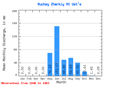
| Statistic | Jan | Feb | Mar | Apr | May | Jun | Jul | Aug | Sep | Oct | Nov | Dec | Annual |
|---|---|---|---|---|---|---|---|---|---|---|---|---|---|
| Mean | 0.00 | 0.00 | 0.00 | 0.00 | 70.10 | 151.07 | 48.75 | 54.67 | 40.47 | 13.62 | 1.41 | 0.07 | 375.74 |
| Standard Deviation | 0.00 | 0.00 | 0.00 | 0.00 | 48.31 | 112.52 | 23.70 | 34.20 | 25.03 | 7.19 | 1.32 | 0.20 | 118.25 |
| Min | 0.00 | 0.00 | 0.00 | 0.00 | 0.78 | 35.23 | 22.53 | 17.33 | 12.58 | 5.89 | 0.00 | 0.00 | 238.15 |
| Max | 0.00 | 0.00 | 0.00 | 0.00 | 135.20 | 373.28 | 98.80 | 166.40 | 123.31 | 38.13 | 4.70 | 0.87 | 702.70 |
| Coefficient of Variation | 0.69 | 0.74 | 0.49 | 0.63 | 0.62 | 0.53 | 0.94 | 3.03 | 0.32 |
 Return to R-Arctic Net Home Page