|
|
|||||||||||||||||
| Point ID: 8041 | Downloads | Plots | Site Data | Code: 1105 |
|
|
|||||||||||||||||
| Download | |
|---|---|
| Site Descriptor Information | Site Time Series Data |
| Link to all available data | |
| View: | Time Series | All |
| Units: | m3/s |
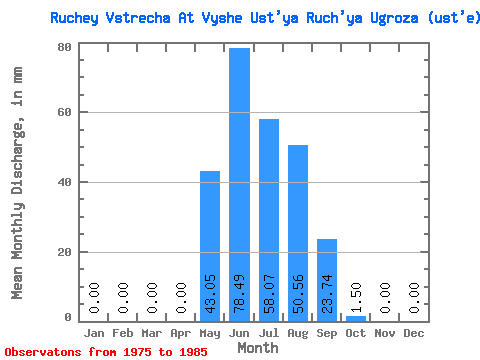
| Statistic | Jan | Feb | Mar | Apr | May | Jun | Jul | Aug | Sep | Oct | Nov | Dec | Annual |
|---|---|---|---|---|---|---|---|---|---|---|---|---|---|
| Mean | 0.00 | 0.00 | 0.00 | 0.05 | 43.14 | 78.49 | 58.02 | 50.38 | 23.56 | 1.27 | 0.00 | 0.00 | 253.66 |
| Standard Deviation | 0.00 | 0.00 | 0.00 | 0.12 | 19.20 | 72.58 | 31.11 | 28.93 | 17.68 | 1.19 | 0.00 | 0.00 | 77.44 |
| Min | 0.00 | 0.00 | 0.00 | 0.00 | 7.51 | 18.89 | 13.02 | 11.51 | 3.88 | 0.00 | 0.00 | 0.00 | 95.86 |
| Max | 0.00 | 0.00 | 0.00 | 0.29 | 67.08 | 204.94 | 104.62 | 95.11 | 55.23 | 3.50 | 0.00 | 0.00 | 352.96 |
| Coefficient of Variation | 2.23 | 0.45 | 0.93 | 0.54 | 0.57 | 0.75 | 0.94 | 0.30 |
 Return to R-Arctic Net Home Page