|
|
|||||||||||||||||
| Point ID: 8040 | Downloads | Plots | Site Data | Code: 1104 |
|
|
|||||||||||||||||
| Download | |
|---|---|
| Site Descriptor Information | Site Time Series Data |
| Link to all available data | |
| View: | Time Series | All |
| Units: | m3/s |
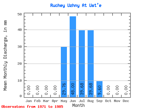
| Statistic | Jan | Feb | Mar | Apr | May | Jun | Jul | Aug | Sep | Oct | Nov | Dec | Annual |
|---|---|---|---|---|---|---|---|---|---|---|---|---|---|
| Mean | 0.00 | 0.00 | 0.00 | 0.00 | 26.45 | 49.92 | 42.98 | 42.98 | 12.16 | 0.66 | 0.00 | 0.00 | 174.03 |
| Standard Deviation | 0.00 | 0.00 | 0.00 | 0.00 | 20.76 | 43.42 | 23.01 | 25.33 | 12.29 | 2.56 | 0.00 | 0.00 | 56.78 |
| Min | 0.00 | 0.00 | 0.00 | 0.00 | 9.92 | 9.60 | 0.00 | 9.92 | 0.00 | 0.00 | 0.00 | 0.00 | 58.44 |
| Max | 0.00 | 0.00 | 0.00 | 0.00 | 89.27 | 144.00 | 79.35 | 89.27 | 38.40 | 9.92 | 0.00 | 0.00 | 243.52 |
| Coefficient of Variation | 0.79 | 0.87 | 0.54 | 0.59 | 1.01 | 3.87 | 0.33 |
 Return to R-Arctic Net Home Page