|
|
|||||||||||||||||
| Point ID: 8037 | Downloads | Plots | Site Data | Code: 1101 |
|
|
|||||||||||||||||
| Download | |
|---|---|
| Site Descriptor Information | Site Time Series Data |
| Link to all available data | |
| View: | Time Series | All |
| Units: | m3/s |
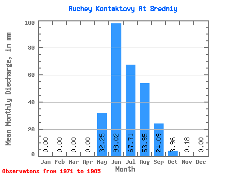
| Statistic | Jan | Feb | Mar | Apr | May | Jun | Jul | Aug | Sep | Oct | Nov | Dec | Annual |
|---|---|---|---|---|---|---|---|---|---|---|---|---|---|
| Mean | 0.00 | 0.00 | 0.00 | 0.00 | 32.21 | 98.09 | 67.75 | 54.02 | 24.12 | 4.00 | 0.13 | 0.00 | 279.29 |
| Standard Deviation | 0.00 | 0.00 | 0.00 | 0.00 | 16.86 | 65.14 | 22.61 | 24.90 | 15.98 | 2.18 | 0.12 | 0.00 | 74.64 |
| Min | 0.00 | 0.00 | 0.00 | 0.00 | 3.88 | 25.01 | 31.87 | 23.76 | 7.67 | 0.94 | 0.00 | 0.00 | 172.25 |
| Max | 0.00 | 0.00 | 0.00 | 0.00 | 65.25 | 217.22 | 104.48 | 93.35 | 68.09 | 9.24 | 0.29 | 0.00 | 401.46 |
| Coefficient of Variation | 0.52 | 0.66 | 0.33 | 0.46 | 0.66 | 0.55 | 0.93 | 0.27 |
 Return to R-Arctic Net Home Page