|
|
|||||||||||||||||
| Point ID: 8036 | Downloads | Plots | Site Data | Code: 1100 |
|
|
|||||||||||||||||
| Download | |
|---|---|
| Site Descriptor Information | Site Time Series Data |
| Link to all available data | |
| View: | Time Series | All |
| Units: | m3/s |
| Statistic | Jan | Feb | Mar | Apr | May | Jun | Jul | Aug | Sep | Oct | Nov | Dec | Annual |
|---|---|---|---|---|---|---|---|---|---|---|---|---|---|
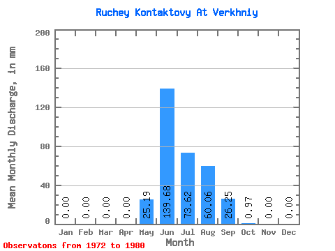
| Mean | 0.00 | 0.00 | 0.00 | 0.00 | 25.25 | 139.48 | 73.79 | 59.92 | 26.18 | 0.87 | 0.00 | 0.00 | 319.46 |
| Standard Deviation | 0.00 | 0.00 | 0.00 | 0.00 | 24.82 | 99.08 | 25.04 | 41.92 | 27.84 | 1.78 | 0.00 | 0.00 | 102.60 |
| Min | 0.00 | 0.00 | 0.00 | 0.00 | 0.00 | 26.25 | 28.57 | 11.91 | 2.34 | 0.00 | 0.00 | 0.00 | 180.72 |
| Max | 0.00 | 0.00 | 0.00 | 0.00 | 68.28 | 334.48 | 110.41 | 116.22 | 83.90 | 5.33 | 0.00 | 0.00 | 475.11 |
| Coefficient of Variation | 0.98 | 0.71 | 0.34 | 0.70 | 1.06 | 2.05 | 0.32 |
 Return to R-Arctic Net Home Page