|
|
|||||||||||||||||
| Point ID: 8034 | Downloads | Plots | Site Data | Code: 1061 |
|
|
|||||||||||||||||
| Download | |
|---|---|
| Site Descriptor Information | Site Time Series Data |
| Link to all available data | |
| View: | Time Series | All |
| Units: | m3/s |
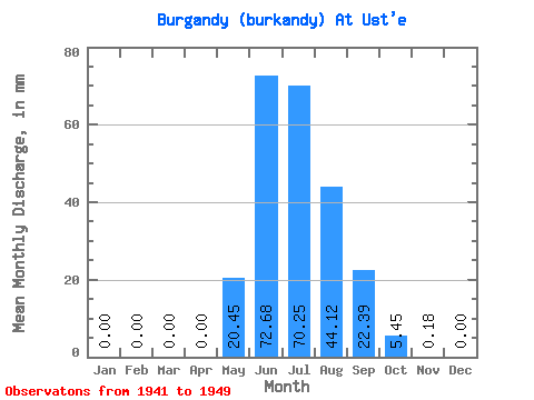
| Statistic | Jan | Feb | Mar | Apr | May | Jun | Jul | Aug | Sep | Oct | Nov | Dec | Annual |
|---|---|---|---|---|---|---|---|---|---|---|---|---|---|
| Mean | 0.00 | 0.00 | 0.00 | 0.00 | 20.45 | 72.69 | 70.24 | 44.12 | 22.39 | 5.45 | 0.18 | 0.00 | 234.40 |
| Standard Deviation | 0.00 | 0.00 | 0.00 | 0.00 | 12.08 | 30.54 | 23.60 | 14.36 | 7.60 | 3.68 | 0.38 | 0.00 | 58.41 |
| Min | 0.00 | 0.00 | 0.00 | 0.00 | 2.54 | 28.96 | 30.34 | 24.93 | 14.93 | 2.35 | 0.00 | 0.00 | 152.50 |
| Max | 0.00 | 0.00 | 0.00 | 0.00 | 38.14 | 138.54 | 101.12 | 67.87 | 35.17 | 13.76 | 1.16 | 0.00 | 298.87 |
| Coefficient of Variation | 0.59 | 0.42 | 0.34 | 0.33 | 0.34 | 0.68 | 2.11 | 0.25 |
 Return to R-Arctic Net Home Page