|
|
|||||||||||||||||
| Point ID: 8010 | Downloads | Plots | Site Data | Code: 3830 |
|
|
|||||||||||||||||
| Download | |
|---|---|
| Site Descriptor Information | Site Time Series Data |
| Link to all available data | |
| View: | Time Series | All |
| Units: | m3/s |
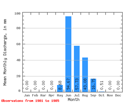
| Statistic | Jan | Feb | Mar | Apr | May | Jun | Jul | Aug | Sep | Oct | Nov | Dec | Annual |
|---|---|---|---|---|---|---|---|---|---|---|---|---|---|
| Mean | 0.00 | 0.00 | 0.00 | 0.00 | 8.68 | 94.67 | 57.72 | 43.08 | 16.75 | 0.51 | 0.00 | 0.00 | 221.06 |
| Standard Deviation | 0.00 | 0.00 | 0.00 | 0.00 | 18.99 | 29.34 | 32.86 | 18.10 | 7.08 | 0.48 | 0.00 | 0.00 | 68.12 |
| Min | 0.00 | 0.00 | 0.00 | 0.00 | 0.00 | 69.19 | 24.60 | 16.09 | 9.42 | 0.01 | 0.00 | 0.00 | 157.15 |
| Max | 0.00 | 0.00 | 0.00 | 0.00 | 42.64 | 141.28 | 102.18 | 62.41 | 26.70 | 1.20 | 0.00 | 0.00 | 332.81 |
| Coefficient of Variation | 2.19 | 0.31 | 0.57 | 0.42 | 0.42 | 0.95 | 0.31 |
 Return to R-Arctic Net Home Page