|
|
|||||||||||||||||
| Point ID: 7989 | Downloads | Plots | Site Data | Code: 3639 |
|
|
|||||||||||||||||
| Download | |
|---|---|
| Site Descriptor Information | Site Time Series Data |
| Link to all available data | |
| View: | Time Series | All |
| Units: | m3/s |
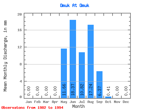
| Statistic | Jan | Feb | Mar | Apr | May | Jun | Jul | Aug | Sep | Oct | Nov | Dec | Annual |
|---|---|---|---|---|---|---|---|---|---|---|---|---|---|
| Mean | 0.00 | 0.00 | 0.00 | 0.00 | 11.66 | 18.36 | 10.82 | 17.25 | 6.38 | 0.41 | 0.00 | 0.00 | 37.65 |
| Standard Deviation | 0.00 | 0.00 | 0.00 | 0.00 | 12.09 | 17.23 | 8.78 | 16.97 | 8.99 | 0.89 | 0.00 | 0.00 | |
| Min | 0.00 | 0.00 | 0.00 | 0.00 | 0.71 | 0.20 | 0.87 | 3.32 | -5.43 | 0.00 | 0.00 | 0.00 | 37.65 |
| Max | 0.00 | 0.00 | 0.00 | 0.00 | 38.77 | 54.80 | 26.02 | 54.33 | 26.66 | 2.42 | 0.00 | 0.00 | 37.65 |
| Coefficient of Variation | 1.04 | 0.94 | 0.81 | 0.98 | 1.41 | 2.17 |
 Return to R-Arctic Net Home Page