|
|
|||||||||||||||||
| Point ID: 7984 | Downloads | Plots | Site Data | Code: 3630 |
|
|
|||||||||||||||||
| Download | |
|---|---|
| Site Descriptor Information | Site Time Series Data |
| Link to all available data | |
| View: | Time Series | All |
| Units: | m3/s |
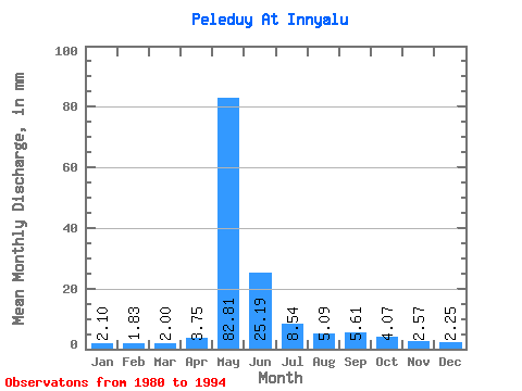
| Statistic | Jan | Feb | Mar | Apr | May | Jun | Jul | Aug | Sep | Oct | Nov | Dec | Annual |
|---|---|---|---|---|---|---|---|---|---|---|---|---|---|
| Mean | 2.10 | 1.85 | 2.00 | 3.75 | 82.80 | 25.19 | 8.54 | 5.09 | 5.61 | 4.07 | 2.57 | 2.25 | 144.84 |
| Standard Deviation | 0.48 | 0.45 | 0.61 | 4.73 | 21.24 | 13.03 | 5.09 | 2.04 | 5.08 | 1.86 | 0.83 | 0.77 | 35.55 |
| Min | 1.44 | 1.10 | 0.86 | 1.09 | 52.19 | 10.97 | 2.93 | 2.08 | 2.11 | 2.14 | 1.50 | 0.56 | 107.37 |
| Max | 3.15 | 2.34 | 2.98 | 19.31 | 111.58 | 53.17 | 18.40 | 9.85 | 22.83 | 8.96 | 4.65 | 4.05 | 237.49 |
| Coefficient of Variation | 0.23 | 0.24 | 0.31 | 1.26 | 0.26 | 0.52 | 0.60 | 0.40 | 0.91 | 0.46 | 0.33 | 0.34 | 0.24 |
 Return to R-Arctic Net Home Page