|
|
|||||||||||||||||
| Point ID: 7981 | Downloads | Plots | Site Data | Code: 3625 |
|
|
|||||||||||||||||
| Download | |
|---|---|
| Site Descriptor Information | Site Time Series Data |
| Link to all available data | |
| View: | Time Series | All |
| Units: | m3/s |
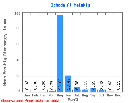
| Statistic | Jan | Feb | Mar | Apr | May | Jun | Jul | Aug | Sep | Oct | Nov | Dec | Annual |
|---|---|---|---|---|---|---|---|---|---|---|---|---|---|
| Mean | 0.03 | 0.00 | 0.00 | 0.79 | 96.67 | 20.47 | 6.38 | 3.12 | 4.69 | 2.43 | 0.43 | 0.13 | 124.75 |
| Standard Deviation | 0.04 | 0.00 | 0.00 | 1.97 | 30.98 | 14.09 | 8.75 | 4.13 | 5.96 | 2.90 | 0.50 | 0.22 | 44.97 |
| Min | 0.00 | 0.00 | 0.00 | 0.00 | 51.09 | 4.27 | 0.39 | 0.20 | 0.35 | 0.31 | 0.04 | 0.00 | 70.16 |
| Max | 0.10 | 0.01 | 0.00 | 5.27 | 143.40 | 44.67 | 29.63 | 13.96 | 17.37 | 8.21 | 1.81 | 0.72 | 171.98 |
| Coefficient of Variation | 1.31 | 1.82 | 2.49 | 0.32 | 0.69 | 1.37 | 1.32 | 1.27 | 1.19 | 1.17 | 1.65 | 0.36 |
 Return to R-Arctic Net Home Page