|
|
|||||||||||||||||
| Point ID: 7961 | Downloads | Plots | Site Data | Code: 3600 |
|
|
|||||||||||||||||
| Download | |
|---|---|
| Site Descriptor Information | Site Time Series Data |
| Link to all available data | |
| View: | Time Series | All |
| Units: | m3/s |
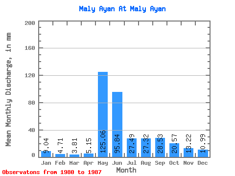
| Statistic | Jan | Feb | Mar | Apr | May | Jun | Jul | Aug | Sep | Oct | Nov | Dec | Annual |
|---|---|---|---|---|---|---|---|---|---|---|---|---|---|
| Mean | 9.04 | 4.75 | 3.80 | 5.14 | 125.06 | 95.83 | 27.47 | 27.33 | 28.55 | 20.58 | 13.22 | 10.99 | 394.35 |
| Standard Deviation | 5.99 | 4.19 | 2.74 | 3.56 | 56.54 | 76.34 | 20.89 | 18.32 | 22.06 | 14.35 | 12.28 | 8.00 | 152.23 |
| Min | 3.78 | 1.70 | 0.35 | 0.00 | 35.37 | 23.78 | 3.78 | 11.34 | 6.27 | 2.70 | 0.21 | 0.59 | 204.01 |
| Max | 18.36 | 12.30 | 8.37 | 10.71 | 184.92 | 229.15 | 70.19 | 65.87 | 72.12 | 38.60 | 35.80 | 21.87 | 639.74 |
| Coefficient of Variation | 0.66 | 0.88 | 0.72 | 0.69 | 0.45 | 0.80 | 0.76 | 0.67 | 0.77 | 0.70 | 0.93 | 0.73 | 0.39 |
 Return to R-Arctic Net Home Page