|
|
|||||||||||||||||
| Point ID: 7959 | Downloads | Plots | Site Data | Code: 3598 |
|
|
|||||||||||||||||
| Download | |
|---|---|
| Site Descriptor Information | Site Time Series Data |
| Link to all available data | |
| View: | Time Series | All |
| Units: | m3/s |
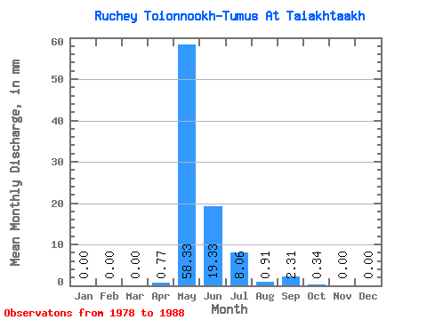
| Statistic | Jan | Feb | Mar | Apr | May | Jun | Jul | Aug | Sep | Oct | Nov | Dec | Annual |
|---|---|---|---|---|---|---|---|---|---|---|---|---|---|
| Mean | 0.00 | 0.00 | 0.00 | 0.73 | 58.34 | 19.33 | 8.03 | 0.95 | 2.26 | 0.32 | 0.00 | 0.00 | 105.06 |
| Standard Deviation | 0.00 | 0.00 | 0.00 | 1.85 | 42.46 | 14.63 | 16.18 | 2.02 | 5.04 | 0.75 | 0.00 | 0.00 | 51.43 |
| Min | 0.00 | 0.00 | 0.00 | 0.00 | 4.77 | 0.99 | 0.00 | 0.00 | 0.00 | 0.00 | 0.00 | 0.00 | 34.44 |
| Max | 0.00 | 0.00 | 0.00 | 5.27 | 127.09 | 36.24 | 41.99 | 6.24 | 15.38 | 2.27 | 0.00 | 0.00 | 203.60 |
| Coefficient of Variation | 2.54 | 0.73 | 0.76 | 2.02 | 2.12 | 2.23 | 2.37 | 0.49 |
 Return to R-Arctic Net Home Page