|
|
|||||||||||||||||
| Point ID: 7946 | Downloads | Plots | Site Data | Code: 3582 |
|
|
|||||||||||||||||
| Download | |
|---|---|
| Site Descriptor Information | Site Time Series Data |
| Link to all available data | |
| View: | Time Series | All |
| Units: | m3/s |
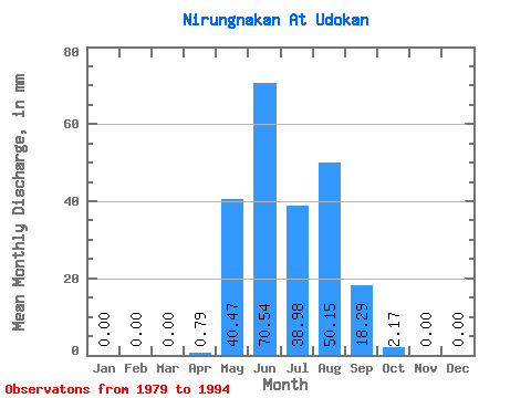
| Statistic | Jan | Feb | Mar | Apr | May | Jun | Jul | Aug | Sep | Oct | Nov | Dec | Annual |
|---|---|---|---|---|---|---|---|---|---|---|---|---|---|
| Mean | 0.00 | 0.00 | 0.00 | 0.80 | 40.47 | 70.55 | 38.97 | 50.14 | 18.28 | 2.17 | 0.00 | 0.00 | 252.29 |
| Standard Deviation | 0.00 | 0.00 | 0.00 | 0.78 | 43.95 | 39.66 | 34.23 | 74.37 | 6.69 | 3.06 | 0.00 | 0.00 | 158.24 |
| Min | 0.00 | 0.00 | 0.00 | 0.00 | 11.84 | 10.82 | 5.38 | 1.04 | 7.69 | 0.00 | 0.00 | 0.00 | 108.39 |
| Max | 0.00 | 0.00 | 0.00 | 1.82 | 188.40 | 158.91 | 131.34 | 297.41 | 31.78 | 11.17 | 0.00 | 0.00 | 577.54 |
| Coefficient of Variation | 0.97 | 1.09 | 0.56 | 0.88 | 1.48 | 0.37 | 1.41 | 0.63 |
 Return to R-Arctic Net Home Page