|
|
|||||||||||||||||
| Point ID: 7940 | Downloads | Plots | Site Data | Code: 3567 |
|
|
|||||||||||||||||
| Download | |
|---|---|
| Site Descriptor Information | Site Time Series Data |
| Link to all available data | |
| View: | Time Series | All |
| Units: | m3/s |
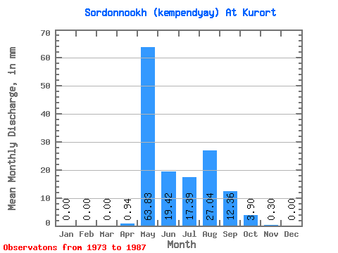
| Statistic | Jan | Feb | Mar | Apr | May | Jun | Jul | Aug | Sep | Oct | Nov | Dec | Annual |
|---|---|---|---|---|---|---|---|---|---|---|---|---|---|
| Mean | 0.00 | 0.00 | 0.00 | 0.92 | 63.81 | 19.41 | 17.38 | 27.04 | 12.38 | 3.88 | 0.29 | 0.00 | 162.47 |
| Standard Deviation | 0.00 | 0.00 | 0.00 | 1.47 | 52.13 | 14.39 | 38.70 | 87.78 | 25.20 | 6.42 | 0.49 | 0.00 | 232.46 |
| Min | 0.00 | 0.00 | 0.00 | 0.00 | 18.47 | 3.53 | 0.72 | 0.20 | 0.60 | 0.00 | 0.00 | 0.00 | 34.66 |
| Max | 0.00 | 0.00 | 0.00 | 3.87 | 219.57 | 62.57 | 144.16 | 319.10 | 94.34 | 24.11 | 1.34 | 0.00 | 856.72 |
| Coefficient of Variation | 1.60 | 0.82 | 0.74 | 2.23 | 3.25 | 2.04 | 1.66 | 1.69 | 1.43 |
 Return to R-Arctic Net Home Page