|
|
|||||||||||||||||
| Point ID: 7938 | Downloads | Plots | Site Data | Code: 3563 |
|
|
|||||||||||||||||
| Download | |
|---|---|
| Site Descriptor Information | Site Time Series Data |
| Link to all available data | |
| View: | Time Series | All |
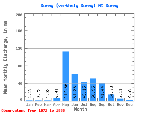
| Units: | m3/s |
| Statistic | Jan | Feb | Mar | Apr | May | Jun | Jul | Aug | Sep | Oct | Nov | Dec | Annual |
|---|---|---|---|---|---|---|---|---|---|---|---|---|---|
| Mean | 1.20 | 0.74 | 1.02 | 5.91 | 112.65 | 61.26 | 43.14 | 50.94 | 41.44 | 14.79 | 5.10 | 2.59 | 357.36 |
| Standard Deviation | 0.63 | 0.55 | 0.71 | 6.58 | 73.02 | 72.56 | 28.61 | 38.55 | 30.30 | 10.29 | 3.18 | 1.46 | 192.10 |
| Min | 0.00 | 0.00 | 0.00 | 0.76 | 11.78 | 9.92 | 6.58 | 7.19 | 3.56 | 0.96 | 0.00 | 0.00 | 62.28 |
| Max | 1.99 | 1.95 | 2.29 | 22.66 | 234.13 | 250.31 | 97.94 | 117.98 | 80.87 | 35.50 | 10.22 | 4.59 | 594.53 |
| Coefficient of Variation | 0.53 | 0.75 | 0.70 | 1.11 | 0.65 | 1.18 | 0.66 | 0.76 | 0.73 | 0.70 | 0.62 | 0.56 | 0.54 |
 Return to R-Arctic Net Home Page