|
|
|||||||||||||||||
| Point ID: 7932 | Downloads | Plots | Site Data | Code: 3530 |
|
|
|||||||||||||||||
| Download | |
|---|---|
| Site Descriptor Information | Site Time Series Data |
| Link to all available data | |
| View: | Time Series | All |
| Units: | m3/s |
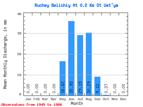
| Statistic | Jan | Feb | Mar | Apr | May | Jun | Jul | Aug | Sep | Oct | Nov | Dec | Annual |
|---|---|---|---|---|---|---|---|---|---|---|---|---|---|
| Mean | 0.00 | 0.00 | 0.00 | 0.00 | 16.61 | 35.93 | 29.11 | 30.30 | 9.13 | 0.45 | 0.00 | 0.00 | 120.82 |
| Standard Deviation | 0.00 | 0.00 | 0.00 | 0.00 | 20.47 | 26.13 | 21.24 | 18.97 | 8.87 | 0.89 | 0.00 | 0.00 | 53.13 |
| Min | 0.00 | 0.00 | 0.00 | 0.00 | 0.37 | 0.54 | 2.03 | 6.83 | 0.89 | 0.00 | 0.00 | 0.00 | 22.31 |
| Max | 0.00 | 0.00 | 0.00 | 0.00 | 112.66 | 91.17 | 90.50 | 88.65 | 37.54 | 5.17 | 0.00 | 0.00 | 251.03 |
| Coefficient of Variation | 1.23 | 0.73 | 0.73 | 0.63 | 0.97 | 1.96 | 0.44 |
 Return to R-Arctic Net Home Page