|
|
|||||||||||||||||
| Point ID: 7921 | Downloads | Plots | Site Data | Code: 3501 |
|
|
|||||||||||||||||
| Download | |
|---|---|
| Site Descriptor Information | Site Time Series Data |
| Link to all available data | |
| View: | Time Series | All |
| Units: | m3/s |
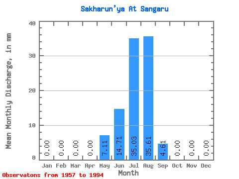
| Statistic | Jan | Feb | Mar | Apr | May | Jun | Jul | Aug | Sep | Oct | Nov | Dec | Annual |
|---|---|---|---|---|---|---|---|---|---|---|---|---|---|
| Mean | 0.00 | 0.00 | 0.00 | 0.00 | 7.11 | 14.71 | 35.04 | 35.61 | 4.61 | 0.00 | 0.00 | 0.00 | 105.29 |
| Standard Deviation | 0.00 | 0.00 | 0.00 | 0.00 | 13.00 | 12.83 | 68.86 | 80.94 | 7.95 | 0.01 | 0.00 | 0.00 | 169.02 |
| Min | 0.00 | 0.00 | 0.00 | 0.00 | 0.00 | 0.00 | 0.00 | 0.19 | 0.00 | 0.00 | 0.00 | 0.00 | 5.05 |
| Max | 0.00 | 0.00 | 0.00 | 0.00 | 65.38 | 42.99 | 418.83 | 495.00 | 33.78 | 0.03 | 0.00 | 0.00 | 947.32 |
| Coefficient of Variation | 1.83 | 0.87 | 1.96 | 2.27 | 1.73 | 5.48 | 1.60 |
 Return to R-Arctic Net Home Page