|
|
|||||||||||||||||
| Point ID: 7914 | Downloads | Plots | Site Data | Code: 3450 |
|
|
|||||||||||||||||
| Download | |
|---|---|
| Site Descriptor Information | Site Time Series Data |
| Link to all available data | |
| View: | Time Series | All |
| Units: | m3/s |
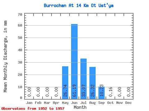
| Statistic | Jan | Feb | Mar | Apr | May | Jun | Jul | Aug | Sep | Oct | Nov | Dec | Annual |
|---|---|---|---|---|---|---|---|---|---|---|---|---|---|
| Mean | 0.00 | 0.00 | 0.00 | 0.00 | 26.74 | 61.19 | 33.07 | 26.31 | 10.22 | 0.17 | 0.00 | 0.00 | 153.88 |
| Standard Deviation | 0.00 | 0.00 | 0.00 | 0.00 | 18.63 | 25.18 | 17.57 | 12.36 | 11.05 | 0.09 | 0.00 | 0.00 | 42.09 |
| Min | 0.00 | 0.00 | 0.00 | 0.00 | 5.82 | 23.44 | 6.99 | 10.95 | 2.21 | 0.05 | 0.00 | 0.00 | 103.19 |
| Max | 0.00 | 0.00 | 0.00 | 0.00 | 52.63 | 92.19 | 54.26 | 39.12 | 29.07 | 0.28 | 0.00 | 0.00 | 209.69 |
| Coefficient of Variation | 0.70 | 0.41 | 0.53 | 0.47 | 1.08 | 0.51 | 0.27 |
 Return to R-Arctic Net Home Page