|
|
|||||||||||||||||
| Point ID: 7907 | Downloads | Plots | Site Data | Code: 3425 |
|
|
|||||||||||||||||
| Download | |
|---|---|
| Site Descriptor Information | Site Time Series Data |
| Link to all available data | |
| View: | Time Series | All |
| Units: | m3/s |
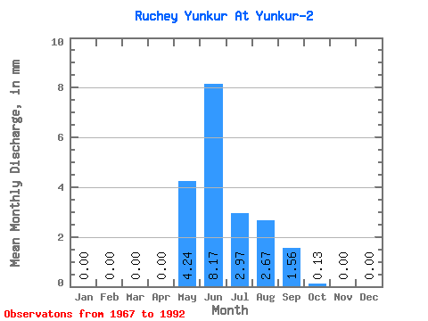
| Statistic | Jan | Feb | Mar | Apr | May | Jun | Jul | Aug | Sep | Oct | Nov | Dec | Annual |
|---|---|---|---|---|---|---|---|---|---|---|---|---|---|
| Mean | 0.00 | 0.00 | 0.00 | 0.00 | 4.25 | 8.19 | 2.96 | 2.66 | 1.56 | 0.13 | 0.00 | 0.00 | 15.53 |
| Standard Deviation | 0.00 | 0.00 | 0.00 | 0.00 | 5.31 | 17.29 | 2.76 | 2.18 | 1.67 | 0.19 | 0.00 | 0.00 | 12.26 |
| Min | 0.00 | 0.00 | 0.00 | 0.00 | 0.00 | 0.00 | 0.00 | 0.00 | 0.00 | 0.00 | 0.00 | 0.00 | 0.88 |
| Max | 0.00 | 0.00 | 0.00 | 0.00 | 23.34 | 80.10 | 9.34 | 8.49 | 6.57 | 0.75 | 0.00 | 0.00 | 42.51 |
| Coefficient of Variation | 1.25 | 2.11 | 0.93 | 0.82 | 1.07 | 1.46 | 0.79 |
 Return to R-Arctic Net Home Page