|
|
|||||||||||||||||
| Point ID: 7876 | Downloads | Plots | Site Data | Code: 3347 |
|
|
|||||||||||||||||
| Download | |
|---|---|
| Site Descriptor Information | Site Time Series Data |
| Link to all available data | |
| View: | Time Series | All |
| Units: | m3/s |
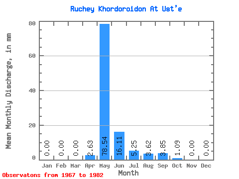
| Statistic | Jan | Feb | Mar | Apr | May | Jun | Jul | Aug | Sep | Oct | Nov | Dec | Annual |
|---|---|---|---|---|---|---|---|---|---|---|---|---|---|
| Mean | 0.00 | 0.00 | 0.00 | 2.56 | 78.62 | 16.06 | 5.19 | 3.68 | 3.77 | 1.06 | 0.00 | 0.00 | 111.85 |
| Standard Deviation | 0.00 | 0.00 | 0.00 | 8.70 | 32.19 | 14.85 | 7.85 | 8.51 | 6.18 | 1.67 | 0.00 | 0.00 | 45.61 |
| Min | 0.00 | 0.00 | 0.00 | 0.00 | 14.77 | 1.40 | 0.00 | 0.00 | 0.00 | 0.00 | 0.00 | 0.00 | 28.89 |
| Max | 0.00 | 0.00 | 0.00 | 35.03 | 123.04 | 52.54 | 27.14 | 32.57 | 22.77 | 6.70 | 0.00 | 0.00 | 197.96 |
| Coefficient of Variation | 3.40 | 0.41 | 0.92 | 1.51 | 2.31 | 1.64 | 1.57 | 0.41 |
 Return to R-Arctic Net Home Page