|
|
|||||||||||||||||
| Point ID: 7860 | Downloads | Plots | Site Data | Code: 3294 |
|
|
|||||||||||||||||
| Download | |
|---|---|
| Site Descriptor Information | Site Time Series Data |
| Link to all available data | |
| View: | Time Series | All |
| Units: | m3/s |
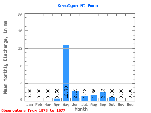
| Statistic | Jan | Feb | Mar | Apr | May | Jun | Jul | Aug | Sep | Oct | Nov | Dec | Annual |
|---|---|---|---|---|---|---|---|---|---|---|---|---|---|
| Mean | 0.00 | 0.00 | 0.00 | 0.56 | 12.70 | 2.19 | 1.14 | 1.36 | 2.13 | 0.96 | 0.00 | 0.00 | 18.92 |
| Standard Deviation | 0.00 | 0.00 | 0.00 | 1.16 | 6.78 | 1.54 | 0.94 | 2.55 | 3.33 | 1.41 | 0.00 | 0.00 | 13.67 |
| Min | 0.00 | 0.00 | 0.00 | 0.00 | 1.89 | 0.25 | 0.30 | 0.04 | 0.02 | 0.00 | 0.00 | 0.00 | 2.48 |
| Max | 0.00 | 0.00 | 0.00 | 2.63 | 20.60 | 3.96 | 2.48 | 5.91 | 7.05 | 2.99 | 0.00 | 0.00 | 35.89 |
| Coefficient of Variation | 2.06 | 0.53 | 0.70 | 0.83 | 1.88 | 1.57 | 1.47 | 0.72 |
 Return to R-Arctic Net Home Page