|
|
|||||||||||||||||
| Point ID: 7858 | Downloads | Plots | Site Data | Code: 3289 |
|
|
|||||||||||||||||
| Download | |
|---|---|
| Site Descriptor Information | Site Time Series Data |
| Link to all available data | |
| View: | Time Series | All |
| Units: | m3/s |
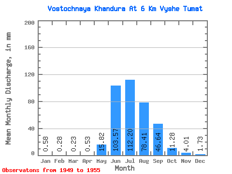
| Statistic | Jan | Feb | Mar | Apr | May | Jun | Jul | Aug | Sep | Oct | Nov | Dec | Annual |
|---|---|---|---|---|---|---|---|---|---|---|---|---|---|
| Mean | 0.58 | 0.28 | 0.23 | 0.53 | 15.82 | 103.57 | 112.18 | 78.40 | 46.65 | 11.28 | 4.01 | 1.73 | 373.58 |
| Standard Deviation | 0.26 | 0.12 | 0.12 | 0.19 | 7.98 | 60.78 | 36.92 | 23.49 | 28.95 | 4.05 | 0.71 | 0.53 | 112.40 |
| Min | 0.21 | 0.11 | 0.06 | 0.26 | 6.96 | 46.26 | 58.50 | 53.15 | 16.63 | 6.67 | 2.87 | 0.82 | 203.02 |
| Max | 0.91 | 0.43 | 0.37 | 0.89 | 25.71 | 193.40 | 166.04 | 113.71 | 86.13 | 17.14 | 5.06 | 2.33 | 541.79 |
| Coefficient of Variation | 0.45 | 0.42 | 0.52 | 0.36 | 0.51 | 0.59 | 0.33 | 0.30 | 0.62 | 0.36 | 0.18 | 0.31 | 0.30 |
 Return to R-Arctic Net Home Page