|
|
|||||||||||||||||
| Point ID: 7857 | Downloads | Plots | Site Data | Code: 3283 |
|
|
|||||||||||||||||
| Download | |
|---|---|
| Site Descriptor Information | Site Time Series Data |
| Link to all available data | |
| View: | Time Series | All |
| Units: | m3/s |
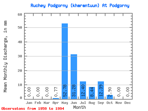
| Statistic | Jan | Feb | Mar | Apr | May | Jun | Jul | Aug | Sep | Oct | Nov | Dec | Annual |
|---|---|---|---|---|---|---|---|---|---|---|---|---|---|
| Mean | 0.00 | 0.00 | 0.00 | 0.72 | 52.81 | 31.22 | 12.37 | 8.49 | 12.38 | 2.85 | 0.00 | 0.00 | 127.78 |
| Standard Deviation | 0.00 | 0.00 | 0.00 | 1.88 | 39.95 | 25.92 | 18.23 | 22.25 | 11.76 | 4.04 | 0.00 | 0.00 | 82.51 |
| Min | 0.00 | 0.00 | 0.00 | 0.00 | 5.14 | 2.81 | 0.00 | 0.00 | 0.00 | 0.00 | 0.00 | 0.00 | 10.49 |
| Max | 0.00 | 0.00 | 0.00 | 7.92 | 199.20 | 92.01 | 60.68 | 113.45 | 44.69 | 13.19 | 0.00 | 0.00 | 317.02 |
| Coefficient of Variation | 2.62 | 0.76 | 0.83 | 1.47 | 2.62 | 0.95 | 1.42 | 0.65 |
 Return to R-Arctic Net Home Page