|
|
|||||||||||||||||
| Point ID: 7856 | Downloads | Plots | Site Data | Code: 3282 |
|
|
|||||||||||||||||
| Download | |
|---|---|
| Site Descriptor Information | Site Time Series Data |
| Link to all available data | |
| View: | Time Series | All |
| Units: | m3/s |
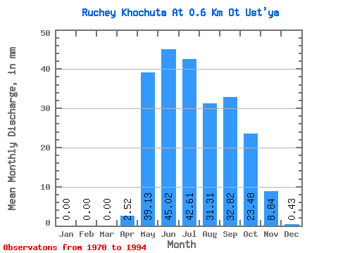
| Statistic | Jan | Feb | Mar | Apr | May | Jun | Jul | Aug | Sep | Oct | Nov | Dec | Annual |
|---|---|---|---|---|---|---|---|---|---|---|---|---|---|
| Mean | 0.00 | 0.00 | 0.00 | 2.37 | 39.26 | 45.15 | 42.59 | 31.51 | 32.86 | 23.26 | 8.84 | 0.36 | 261.37 |
| Standard Deviation | 0.00 | 0.00 | 0.00 | 3.98 | 26.08 | 40.89 | 38.53 | 51.25 | 42.66 | 21.39 | 18.71 | 1.01 | 178.67 |
| Min | 0.00 | 0.00 | 0.00 | 0.00 | 0.87 | 1.68 | 0.00 | 0.00 | 0.42 | 0.00 | 0.00 | 0.00 | 54.65 |
| Max | 0.00 | 0.00 | 0.00 | 13.46 | 95.64 | 155.69 | 160.85 | 252.15 | 201.97 | 82.60 | 79.95 | 3.91 | 736.49 |
| Coefficient of Variation | 1.68 | 0.66 | 0.91 | 0.91 | 1.63 | 1.30 | 0.92 | 2.12 | 2.82 | 0.68 |
 Return to R-Arctic Net Home Page