|
|
|||||||||||||||||
| Point ID: 7852 | Downloads | Plots | Site Data | Code: 3263 |
|
|
|||||||||||||||||
| Download | |
|---|---|
| Site Descriptor Information | Site Time Series Data |
| Link to all available data | |
| View: | Time Series | All |
| Units: | m3/s |
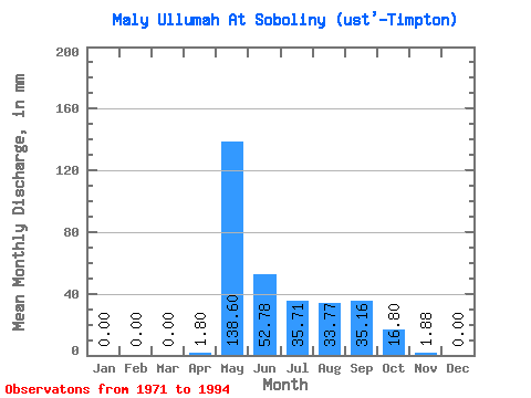
| Statistic | Jan | Feb | Mar | Apr | May | Jun | Jul | Aug | Sep | Oct | Nov | Dec | Annual |
|---|---|---|---|---|---|---|---|---|---|---|---|---|---|
| Mean | 0.00 | 0.00 | 0.00 | 1.81 | 138.56 | 52.80 | 35.69 | 33.75 | 35.16 | 16.79 | 1.88 | 0.00 | 327.68 |
| Standard Deviation | 0.00 | 0.00 | 0.00 | 3.84 | 43.22 | 28.16 | 29.62 | 30.44 | 22.12 | 11.83 | 2.15 | 0.00 | 81.23 |
| Min | 0.00 | 0.00 | 0.00 | 0.00 | 76.01 | 14.54 | 7.34 | 2.12 | 4.88 | 0.00 | 0.00 | 0.00 | 165.18 |
| Max | 0.00 | 0.00 | 0.00 | 14.54 | 206.82 | 117.20 | 147.60 | 125.50 | 74.42 | 43.31 | 7.27 | 0.00 | 455.87 |
| Coefficient of Variation | 2.13 | 0.31 | 0.53 | 0.83 | 0.90 | 0.63 | 0.70 | 1.14 | 0.25 |
 Return to R-Arctic Net Home Page