|
|
|||||||||||||||||
| Point ID: 7851 | Downloads | Plots | Site Data | Code: 3262 |
|
|
|||||||||||||||||
| Download | |
|---|---|
| Site Descriptor Information | Site Time Series Data |
| Link to all available data | |
| View: | Time Series | All |
| Units: | m3/s |
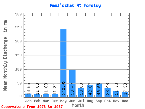
| Statistic | Jan | Feb | Mar | Apr | May | Jun | Jul | Aug | Sep | Oct | Nov | Dec | Annual |
|---|---|---|---|---|---|---|---|---|---|---|---|---|---|
| Mean | 13.64 | 11.07 | 11.09 | 11.32 | 240.84 | 98.42 | 33.08 | 42.62 | 49.72 | 33.53 | 21.69 | 17.32 | 578.40 |
| Standard Deviation | 7.42 | 6.39 | 6.31 | 6.93 | 120.27 | 95.56 | 14.59 | 19.29 | 25.97 | 17.77 | 9.20 | 7.41 | 142.78 |
| Min | 0.12 | 0.00 | 0.00 | 0.00 | 0.00 | 1.14 | 15.75 | 15.75 | 12.71 | 8.53 | 5.72 | 4.20 | 261.70 |
| Max | 24.94 | 23.92 | 23.63 | 26.68 | 413.51 | 288.42 | 57.76 | 76.14 | 91.48 | 70.89 | 36.85 | 30.19 | 780.23 |
| Coefficient of Variation | 0.54 | 0.58 | 0.57 | 0.61 | 0.50 | 0.97 | 0.44 | 0.45 | 0.52 | 0.53 | 0.42 | 0.43 | 0.25 |
 Return to R-Arctic Net Home Page