|
|
|||||||||||||||||
| Point ID: 7844 | Downloads | Plots | Site Data | Code: 3254 |
|
|
|||||||||||||||||
| Download | |
|---|---|
| Site Descriptor Information | Site Time Series Data |
| Link to all available data | |
| View: | Time Series | All |
| Units: | m3/s |
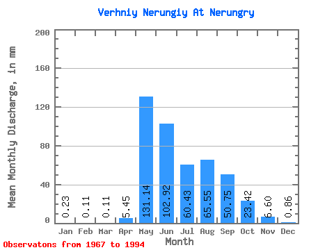
| Statistic | Jan | Feb | Mar | Apr | May | Jun | Jul | Aug | Sep | Oct | Nov | Dec | Annual |
|---|---|---|---|---|---|---|---|---|---|---|---|---|---|
| Mean | 0.23 | 0.11 | 0.11 | 5.45 | 131.12 | 102.92 | 60.42 | 65.54 | 50.75 | 23.41 | 6.60 | 0.86 | 464.61 |
| Standard Deviation | 1.02 | 0.48 | 0.45 | 7.12 | 32.08 | 54.73 | 34.01 | 36.56 | 26.29 | 12.78 | 3.45 | 1.17 | 139.94 |
| Min | 0.00 | 0.00 | 0.00 | 0.00 | 62.97 | 27.56 | 17.71 | 17.80 | 20.34 | 8.56 | 0.00 | 0.00 | 315.42 |
| Max | 4.58 | 2.08 | 2.03 | 28.22 | 195.76 | 233.77 | 149.15 | 140.68 | 103.35 | 49.66 | 12.96 | 4.92 | 821.54 |
| Coefficient of Variation | 4.42 | 4.36 | 4.22 | 1.31 | 0.24 | 0.53 | 0.56 | 0.56 | 0.52 | 0.55 | 0.52 | 1.37 | 0.30 |
 Return to R-Arctic Net Home Page